This large settlement mound (höyük), originally named Karahöyük in common with many other ancient mounds in Turkey, lies 20 kilometers northeast of the city of Kayseri (Roman Caesarea) in Cappadocia, a short distance southeast of the Kızıl Irmak (Red River), in Hittite times Marrassantiya and in Greco-Roman times Halys. One of the most important excavated sites in Anatolia, Kültepe is of special relevance for this dictionary, owing to its certain identification as the city of Nesa, which in its turn can be equated with Kanes, after Kussara, the first center of Hittite political and military power on the Anatolian plateau. Excavated since 1948 by an expedition directed by Tahsin Özgüç, of the University of Ankara, and sponsored by the Turkish Historical Foundation, it had been the site of earlier excavations between World Wars I and II under Bedrich Hrozny of Prague.
As happens all too often in the Near East, it was through the appearance of antiquities in the markets of Constantinople (Istanbul) and further afield, as well as locally, that scholarly attention was first drawn to south central Anatolia, Cappadocia in GrecoRoman times. Both inscribed clay tablets and distinctive painted pottery surfaced in considerable quantities, some 3,000 tablets in all, both categories being described as “Cappadocian.” This Cappadocian ware is now commonly termed Alışar III ware, having been found in that excavated mound in stratified context. This pottery and these tablets have found their way into a number of museums and private collections around the world, unlike the material from the official excavations at Kültepe, now displayed in Ankara and among the major attractions of the museum. Hrozny, a brilliant philologist, had been led to believe that this was the source of the Cappadocian tablets, though as a field archaeologist he found himself out of his depth. During his campaign of excavations at Kültepe (“ash mound”) he eventually unearthed some 600 tablets, among them finding references which proved he had located the ancient city of Kanes, whose full importance was not yet realized.
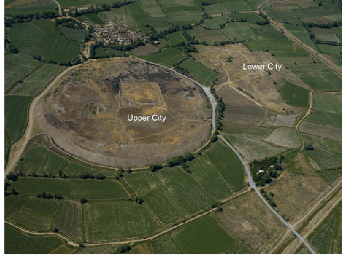
It was, however, some time before he stumbled upon the major feature of this large site, the presence at the foot of the main mound of an extensive low platform, not immediately recognizable as an outer, lower area of the town. He might not have located it when he did, had it not been for a disgruntled villager who came to Hrozny and divulged the secret of the area whence his fellow villagers were extracting clay tablets for sale in the markets. This was to prove to be the site of the greatest Old Assyrian trading community (karum), from which some 15,000 tablets and innumerable other finds have subsequently been recovered by the Turkish expedition.
There is a very long sequence of occupation levels in the main mound, or citadel, of Kültepe, from the Chalcolithic period (fourth millennium BC) down into the Iron Age (first millennium BC). For our purposes the strata from the later Early Bronze Age till the end of the Late Bronze Age are especially significant, the Iron Age also being not without interest. It is apparent that the karum of Kanes was first built and inhabited before the arrival of the Assyrian merchants and the organization of the Old Assyrian trade, for the earliest levels (Karum IVIII) are completely devoid of clay tablets. One theory is that tablets of wood, mentioned in later Hittite texts, may have been in use: if so, this would tend to add weight to the suggestion of an Anatolian, more specifically Luwian, presence here. But without further evidence this remains a matter of enlightened guesswork.
The city of Kültepe-Kanes, contemporary with Level II of the karum and thus dating ca.20501950 BC or a little later, was protected by two defensive lines, the inner wall being built on large unhewn stones, reused in the later defenses of Kanes IB attributable to Anitta, son of Pithana. Among the buildings excavated in the city is a likely palace, with residential quarters and a large paved open square. A palace and five temples are mentioned in the tablets. The entire city and the karum outside the walls were burnt in a violent destruction, conceivably the result of a Hittite attack, although Anitta’s association with Kanes IB and the intervening phase of Kanes IC make it chronologically unlikely to have been attributable to Pithana. The stratigraphy of the city, however, does not indicate any desertion of the site between Kanes II and IB, in spite of the destruction of Kanes II. The palace containing tablets of Warsama, king of Kanes, however, most probably belongs to a phase (IC) when the karum was abandoned, and the merchants had withdrawn within the walls of the Anatolian city, if they had not indeed retreated to Assur. A bronze spearhead with typically Anatolian bent tang bearing the inscription “Palace of Anitta the king” was recovered from a public building within the city in Kanes IB context, adding weight to the claims made in the Anitta Text. In the karum of Kanes the orientation of streets and many buildings remained essentially the same from Level II through IB IA. The buildings all have andesite footings up to floor level only, with mud-brick walls above, though the stonework was in some places carried higher, as behind kitchen ovens. The whole character of the buildings was Anatolian, with no trace of influence from Assyria, the houses being plastered and whitewashed. There is no evidence of gabled roofs. Details such as door jambs, charred remains of wooden door frames and pivot stones demonstrate the access to buildings. Stone paving was used where water was much in use. The majority of houses in Level II of the karum either have two rooms and a rectangular plan or two rooms opening on to a large main room or many rooms off a corridor. Houses were extended as required, presumably with the growth of the household, often with walls set at irregular angles. The population was evidently increasing. Five districts have been identified in the areas occupied by the merchants’ houses, with varying yields of tablets, while other houses excavated 1.5 kilometers to the south contained none.
The significance of this can only be surmised. The makeup of the population of each district can be estimated from its tablets. Most of the Assyrians lived in the first and second districts, being in the majority in the third and fifth districts, alongside native Anatolian merchants. Only the fourth district was perhaps exclusively Anatolian, and the native houses yielded notably fewer tablets. The major archives were housed in the north, northeast and central areas of the karum.
Another area was devoted to workshops and supporting services in the southeast part of the karum, where native householders mostly dwelt. Workshops occur in widely separated parts of the karum, not grouped all together, though no bit karim has been found, this being known only from the tablets. Much evidence remains to be uncovered in the form of more workshops as well as in the thousands of as yet unpublished tablets, which must include references to copper, gold and silver artifacts. Tools, weapons and decorative items of metal, stone and terracotta were manufactured by the craftsmen, no doubt following traditional practices dating back well before the arrival of the Assyrian merchants.
One workshop of the later period (IB) yielded portable and large fixed molds, crucibles, blow-pipes and pot-bellows, indicating metallurgy on an organized footing. It would be mistaken to suggest that it was solely owing to the arrival of the foreign traders from Assur that the level of sophistication in the economy of central Anatolia was attained. More probably a network of trade routes had evolved through the activities of native Anatolian merchants, with the Assyrian newcomers being adept at profiting from established business networks. Kanes had a long history of urban life, the growth of trade in Anatolia emerging during the Early Bronze III period, whose beginning in the midthird millennium BC could be said to mark a cultural watershed not repeated until the advent of the Iron Age in the 12th century BC.
The characteristic Alışar III (Cappadocian) ware appears at Kültepe in the levels termed Early and Middle Cappadocian, continuing through the Late Cappadocian phase, which includes the first two levels (IVIII) of the karum of Kanes. This painted pottery underwent three phases of development conforming with the sequence of levels at Kanes. It is noteworthy that it was in the Early Cappadocian phase, long before the arrival of Assyrian merchants, that the Anatolian city contained a public building of megaron plan, either a temple or a palace, suggesting western influence on central Anatolia. Could this have been an outcome of the Luwian migrations? The vicissitudes of Anatolian society, with growing conflicts between the various minor kingdoms perhaps in part stimulated by competition to enjoy the benefits accruing from the presence of foreign merchants able to pay tolls to allow safe passage of their caravans, had driven the Assyrian inhabitants of the karum of Kanes away.
The perimeter wall surrounding the karum of Kanes IB suggests the necessity of effective protection for the merchants returning to Kanes and in fact extending their trade to other merchant colonies. How much significance is to be attached to the smaller number of tablets found in karum IB compared with karum II is not entirely clear. What is evident is that the second period of Assyrian activity at Kanes lasted a shorter time, on the evidence of limmu names on the tablets, than the first period (karum II). After the first destruction the period of desertion of the karum (IC) probably lasted not less than 50 years, seeing that graves of this time dug into the ruins of karum II were evidently unknown to the inhabitants of the reoccupied colony (karum IB), not being robbed of their contents.
Though there are fewer tablets to reveal details of the Old Assyrian trade in the time of karum IB, it would be mistaken to conclude that this trade had shrunk in volume or variety. Two factors indicate the contrary: first, the expansion of the area of the ka- rum of Kanes to a diameter of over one kilometer, within a wall built on a footing of massive andesite blocks, at the same time as the native Anatolian city grew in size; second, the establishment of other trading posts or colonies, each a karum, at Alışar II, Boğazköy (Hattusa) and Acemhöyük (Burushattum).
The relative chronology of Kültepe-Kanes is greatly clarified by limmu names synchronizing Kültepe IB, Alışar II and Tell Chagar Bazar in the Khabur valley with the reign of Samsi-Adad I of Assyria (1813-1781 BC), overlapping with that of Hammurabi of Babylon (17921750 BC). The following absolute chronology for the successive periods of the karum of Kültepe-Kanes therefore seems plausible: Kültepe II, ca.2050/20001900 BC; Kültepe IC, ca.19001850 BC; Kültepe IB, ca.18501800 BC or slightly later; Kültepe IA, ending ca.1750 BC. The final phase of the karum (IA) was but a pale reflection of what had gone before. It was undoubtedly owing to growing unrest and insecurity for the caravans with discord among the Anatolian kingdoms, rather than any economic changes in Assyria, that the Old Assyrian trade finally came to an end. A brief dark age descended upon the Anatolian plateau, to be lifted a century later under Hattusili I. Never again, however, was such a sophisticated commercial network to flourish in the lands destined to come under Hittite rule. The state would step in where the great merchant family firms had once ruled.
