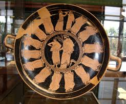
Procession of male pairs (possibly Apaturia festival), Attic red-figure kylix, ca. 480 BC (by User:Bibi Saint-Pol via Wikimedia Commons)
(Ἀπατούρια), an ancient Greek festival held annually by all the Ionian towns except Ephesus and Colophon (Herodotus i. 147). At Athens it took place in the month of Pyanepsion (October to November), and lasted three days, on which occasion the various phratries (i.e. clans) of Attica met to discuss their affairs. The name is a slightly modified form of ἀπατόρια = ἁμαπατόρια, ὁμοπατόρια, the festival of “common relationship.” The ancient etymology associated it with ἀπάτη (deceit), a legend existing that the festival originated in 1100 B.C. in commemoration of a single combat between a certain Melanthus, representing King Thymoetes of Attica, and King Xanthus of Boeotia, in which Melanthus successfully threw his adversary off his guard by crying that a man in a black goat’s skin (identified with Dionysus) was helping him (Schol. Aristophanes, Acharnians, 146). On the first day of the festival, called Dorpia or Dorpeia, banquets were held towards evening at the meeting-place of the phratries or in the private houses of members. On the second, Anarrhysis (from ἀναρρύειν, to draw back the victim’s head), a sacrifice of oxen was offered at the public cost to Zeus Phratrius and Athena. On the third day, Cureotis (κουρεῶτις), children born since the last festival were presented by their fathers or guardians to the assembled phratores, and, after an oath had been taken as to their legitimacy and the sacrifice of a goat or a sheep, their names were inscribed in the register. The name κουρεῶτις is derived either from κοῦρος, that is, the day of the young, or less probably from κείρω, because on this occasion young people cut their hair and offered it to the gods. The victim was called μεῖον. On this day also it was the custom for boys still at school to declaim pieces of poetry, and to receive prizes (Plato, Timaeus, 21 b). According to Hesychius these three days of the festival were followed by a fourth, called ἐπίβδα, but this is merely a general term for the day after any festival.
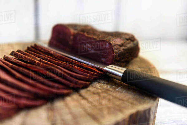
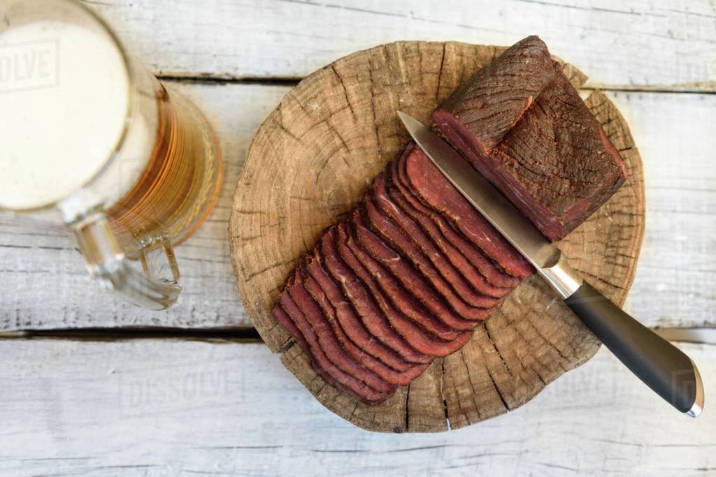
pastrami beer in a glass knife on a wooden table contributor: Omelnickiy
The Turkish horsemen of Central Asia used to preserve meat by placing slabs of it in pockets on the sides of their saddles, where it would be pressed by their legs as they rode. This pressed meat was the forerunner of today’s pastirma, a term which literally means ‘being pressed’ in Turkish, and is the origin of the Italian pastrami. Pastirma is a kind of cured beef, the most famous being that made in the town of Kayseri in central Turkey.
The 17th century Turkish writer Evliya Çelebi praised the spiced beef pastirma of Kayseri in his Book of Travels, and Kayseri pastirma is still regarded as the finest of all. Good quality pastirma is a delicacy with a wonderful flavour, which may be served in slices as a cold hors d’oeuvre or cooked with eggs, tomatoes and so on. Although pastirma may also be made with mutton or goat’s meat, beef is preferred. Cattle, mainly from the eastern province of Kars, are brought to Kayseri, where they are slaughtered and the meat made into pastirma at factories northwest of the city. The different cuts of meat produce different types of pastirma, 19 varieties from a medium-sized animal and 26 from a large. Extra fine qualities are those made from the fillet and contre-fillet, fine qualities are made from cuts like the shank, leg, tranche and shoulder, and second quality from the leg, brisket, flank, neck and similar cuts. The many tons of pastirma produced in Kayseri is almost all sold for domestic consumption all over Turkey.
Istanbul and Adana are the provinces with the largest consumption. The meat undergoes a series of processes lasting about a month. The freshly slaughtered meat rests at room temperature for 4-8 hours before being divided into joints suitable for pastirma making. These are slashed and salted on one side, stacked, and left for around 24 hours. They are then salted on the other side, stacked and left for a further 24 hours. Then the joints are rinsed in plenty of water to remove the excess salt, and dried in the open air for a period varying between three and ten days, depending on the weather. After some further processing, the meat is hung up to dry again, this time in the shade and spaced out so that the joints do not a touch one another. After 3-6 days, they are covered with a paste of ground spices known as çemen, and left to cure for 10-24 hours in hot weather, and 1-2 days in cold weather. Then the excess çemen is removed, leaving a thin layer, and the joints dried again. Finally the pastirma is ready for the table. The çemen paste covering the slabs of pastirma is both an important factor in the flavour, and protects the meat from drying and spoiling by contact with the air, which would cause the fat in the pastirma to oxidise and give a bitter flavour. ÿemen is composed of crushed classical fenugreek seeds, garlic and chilli pepper mixed to a paste with a little water. Çemen paste is also sold separately as a savoury paste for spreading on bread. When buying pastirma, note that the redder the colour, the fresher the pastirma. Over time it takes on a browner tone, and becomes firmer in texture. Good quality pastirma, whether fresh or mature, is delicious, and it is only a matter of taste which you prefer. Gourmets do not approve of pastirma sliced by machine but insist on the thin slices being cut by hand with a sharp meat knife. They also reject ready cut slices of pastirma as sold packaged in some delicatessens and supermarkets. Pastirma is delicious with fresh crusty bread, grilled lightly over charcoal, fried in butter with eggs or in layered pastry börek. Bean stew with pieces of pastirma is another popular dish in Turkey.
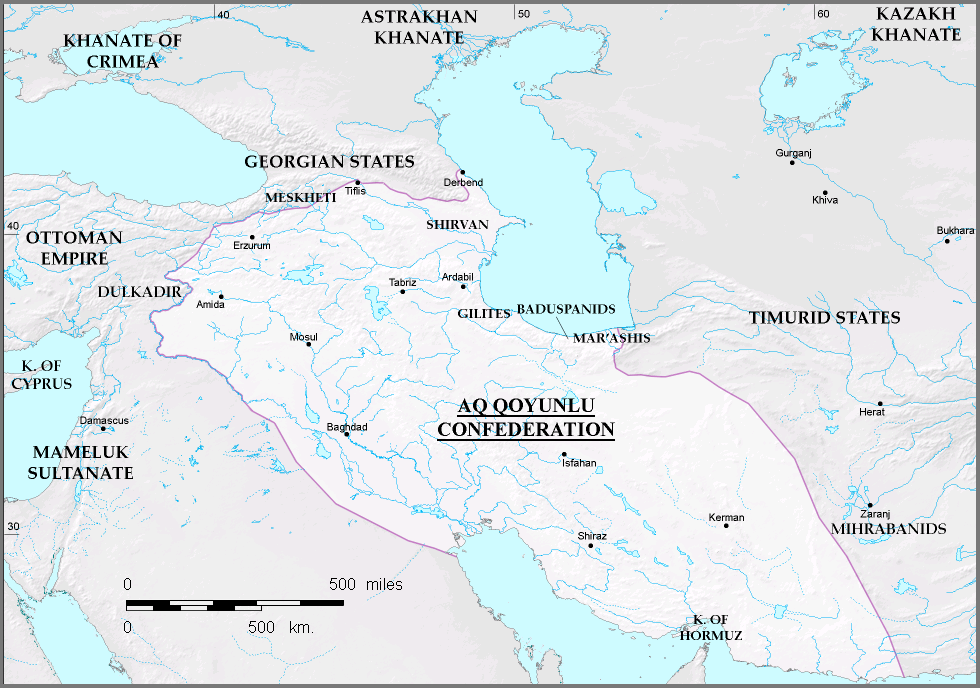
The Ak Koyunlu was one of two rival Turkoman federations, or dynasties (the other being the Kara Koyunlu, or Black Sheep), that ruled parts of Kurdistan during much of the 15th century after the death of the great Mongol conqueror Tamerlane in 1405. Early on, the Sunni Ak Koyunlu had Amed (Di-yarbakir ) as their capital, while the Shia Kara Koyunlu had their center northeast of Lake Van. The Kurds did not play a major role in the armed struggles of the two.
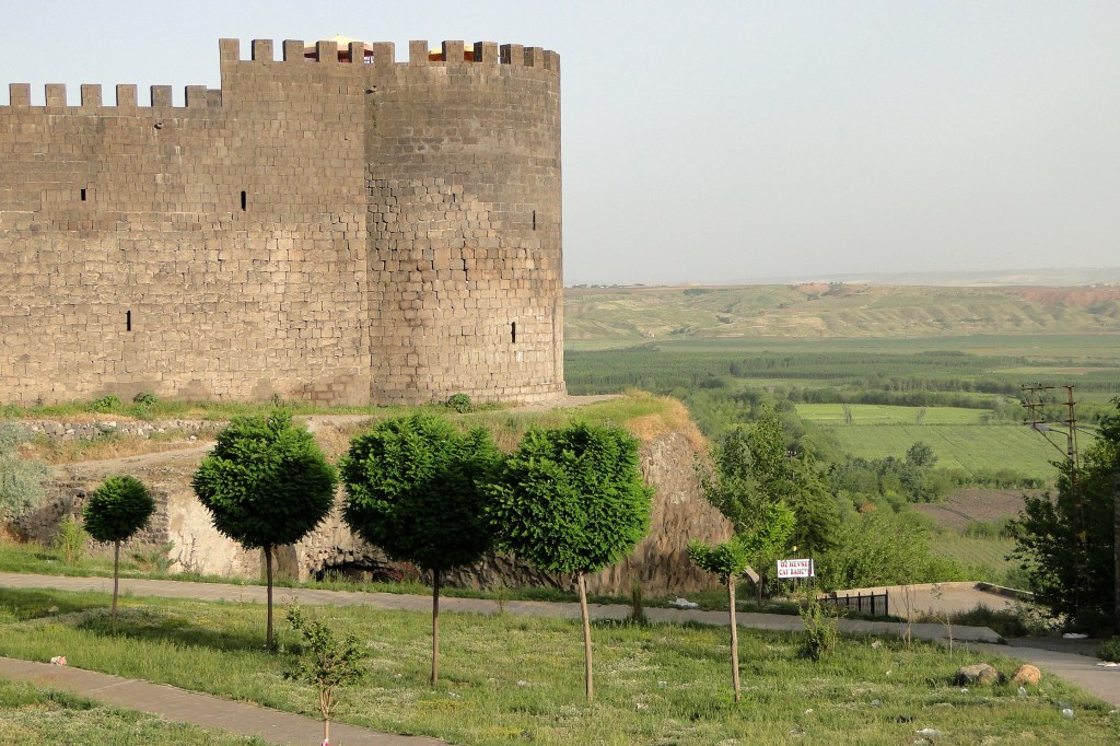
Keçi Burcu, the Goat Tower, a section of the city wall of Diyarbakir photographed by Adam Jones from Kelowna, BC, Canada
In 1467, the able Ak Koyunlu leader Uzun Hasan destroyed his rival Kara Koyunlu federation and eventually extended his power over most of Kurdistan. According to the Sharafnama , Uzun Hasan then “took it upon himself to exterminate the leading families of Kurdistan, especially those who had shown themselves devoted to or subjects of the Kara Koyunlu sultans.” He made his new capital in Tabriz in what is now Iran . After Uzun Hasan’s death, the Iranian Safavid leader Ismail destroyed the Ak Koyunlu in 1502 and proclaimed himself shah.
The origin of the Āq Qoyunlū tribes likewise remains obscure. Certain groups may have migrated from Central Asia to Anatolia in the 5th/11th century under Saljuq leadership and others in the wake of the 7th/13th-century Mongol invasion. By the end of the Il-khanid period in the mid-8th/14th century, the Āq Qoyunlū were migrating between summer pastures (yeylāq) in Armenia around Sinir, east of Bayburt, and winter pastures (qešlāq) around Kiḡi, Palu, and Ergani in Dīār Bakr.
Their political organization was loose. The highest decision-making authority was a council (kengač) of amirs and tribal chiefs (boy ḵānları) who determined military matters and the recurrent issue of succession to the sultanate; the council’s decisions were binding on the sultan. Military and political control of the adjacent villages and towns, necessary for the safety of the pasturage, was maintained by the army, which consisted largely of tribal levies supporting themselves through their own lands and booty. In addition, the sultan maintained a force of paid personal guards (ḵawāṣṣ) who were recruited from several different nomadic and semi-nomadic groups. The revenue of the Āq Qoyunlū came from taxes and dues levied on the sedentary population of Armenians, Kurds, and Arabs, as well as tolls collected along the main trade routes through eastern Anatolia.
Their territory bordered on lands occupied by other Turkman confederation, namely the Qara Qoyunlū area north of Lake Van, the steppe grazed by the Döḡer east of the middle Euphrates around Rohā (Orfa), and the Ḏu’l-Qadr region west of the river. The Ḏu’l-Qadr confederation had submitted to the suzerainty of the Egyptian Mamluks, whose empire thus stretched up to Malaṭya. Further west lay the Qaramān principality and, north of it, the Eretna principality centered on Kayseri and Sīvās, the strongest of the small states formed in Central Anatolia after the collapse of the Il-khanid Empire. To the north of the Āq Qoyunlū were the Christian kingdoms of Trebizond and Georgia.
In the decade 740-50/1339-49 there were frequent armed clashes between the forces of Trebizond and those of Ṭūr-ʿAlī b. Pahlavān, the first Āq Qoyunlū leader mentioned in mutually independent sources. Peace was arranged in 753/1352 through the marriage of Maria Komnene, a sister of the ruler of Trebizond, Alexios III (1349-90), to Ṭūr-ʿAlī’s son Faḵr-al-dīn Quṭlu. Renewed matrimonial links in later generations maintained the peace, and Trebizond was free from Āq Qoyunlū attacks until it fell to the Ottomans in 865/1461. Ṭūr-ʿAlī died some time between 753/1352 and 764/1363. Under his successor Quṭlu, the Āq Qoyunlū began to intervene in the internal conflicts of the Eretna state. They became its nominal vassals in 783/1381 but supported rebellious military chiefs at Arzanǰān (Erzincan) when Qāżī Borhān-al-dīn (also a prominent poet in Turkish) made himself sultan at Sīvās. When Quṭlu died in 791/1389, the leadership first passed to his son Aḥmad, but Aḥmad’s reckless wavering in the struggles between Sīvās and Arzanǰān finally led to his replacement by his brother Qara Yoluz (or Yülük) ʿOṯmān Beg (on this name, see Roemer, “Das turkmenische Intermezzo,” p. 271, n. 26). In 800/1398 Qara ʿOṯmān revolted against Qāżī Borhān-al-dīn and killed him in battle.
Disorders in northern Syria following the deaths of Qāżī Borhān-al-dīn and the Mamluk sultan Barqūq (r. 784-801/1382-99) gave occasion for conflict between the expanding Ottoman power and the westward-moving conqueror Tīmūr. Voluntarily joining Tīmūr in 802/1399-1400, Qara ʿOṯmān led the vanguard in Tīmūr’s campaigns against Sīvās, whose defenders received Ottoman support (802-03/1402), and against the Mamluk dependencies; he also participated in the battle of Ankara (804/1402), which ended in a crushing defeat for the Ottomans. In recompense, Tīmūr granted him the rank of amir, confirmed his leadership of the Āq Qoyunlū confederation, and made the Bayandor family custodians of the
of the fortress city of Āmed (Dīār Bakr) which before 796/1394 had been held by the Artuqids, a clan of the Döḡer tribe. This is apparently how the Āq Qoyunlū first came into possession of Āmed, which was to be their capital for almost seventy years.
After Tīmūr’s death in 807/1405, Qara ʿOṯmān maintained good relations with his successors. By contrast, the Qara Qoyunlū who had been forcibly subdued by Tīmūr, shook off Timurid suzerainty. Under Qara Yūsof, their leader from 792/1390 to 823/1420, they expelled Tīmūr’s grandson Abū Bakr and killed the latter’s father, Mīrānšāh, the governor of Azerbaijan; they then defeated the Jalayerids to gain control of Baghdad and ʿErāq-e ʿArab (Mesopotamia), conquered parts of Georgia, and penetrated deeper into Iran. The Timurid sultan Šāhroḵ was obliged to launch three campaigns (823-24/1420-21, 832/1429, and 838-39/1434-35) to check their expansion and reimpose his suzerainty. Šāhroḵ’s interventions, together with conflicts among the sons of Qara Yūsof, who had died at the time of the first campaign, weakened the position of the Qara Qoyunlū. In the following years they lost large areas in the west to the Āq Qoyunlū.
Between 823/1420 and Qara ʿOṯmān’s death in 839/1435, the Āq Qoyunlū established their authority in Armenia and Dīār Bakr and moved into Dīār Możar and the western part of Dīār Rabīʿa, an expansion which brought them in conflict with the formerly friendly Egyptian Mamluk sultanate. Accordingly, the Qara Qoyunlū allied themselves with Egypt while the Āq Qoyunlū joined with the Timurids, who were then contesting Egyptian hegemony in the Red Sea; Qara ʿOṯmān also provided support for Šāhroḵ’s expeditions into Azerbaijan. During the third campaign, the aging Āq Qoyunlū leader, at Šāhroḵ’s behest, challenged Qara Yūsof’s son Eskandar to battle near Erzurum, but suffered a severe defeat; he was put to death in Ṣafar, 839/August-September, 1435, and his head was sent by Eskandar to the Mamluk sultan Barsbay (r. 825-41/1422-38) in Cairo.
Qara ʿOṯmān was the real founder of the Āq Qoyunlū state. Under his rule, the confederation not only acquired more territory but also gained support through additional tribes drawn to him by his successes. There are indications that the mainly Christian sedentary inhabitants were not totally excluded from the economic, political, and social activities of the Āq Qoyunlū state and that Qara ʿOṯmān had at his command at least a rudimentary bureaucratic apparatus of the Iranian-Islamic type. Even so, the Turkman military elite clearly remained dominant. From 827/1424 onward, in the hope of counteracting the centrifugal tendencies inherent in a tribal confederation and making the principality more cohesive, Qara ʿOṯmān assigned newly conquered territories to his sons rather than to tribal chefs, but this policy did not produce the expected results (Wood, The Aqquyunlu, pp. 66-70).
Qara ʿOṯmān’s death was followed by prolonged succession struggles in which not only the Mamluks, who had gained temporary recognition from some of the Āq Qoyunlū chiefs, but also the Ottomans, intervened. Qara ʿOṯmān’s designated successor, ʿAlī, could not hold his ground against the claims of his brothers, uncles, and cousins, and in 841/1438-39 he abdicated and went into voluntary exile in Egypt. His brother Ḥamza was then the most powerful Āq Qoyunlū chief, but he died in 848/1444 before he had been able to eliminate all rivals. The struggle for leadership resumed between Shaikh Ḥasan, a son of Qara ʿOṯmān, and ʿAlī’s son Jahāngīr. The situation in eastern Anatolia became critical when Šāhroḵ, the Āq Qoyunlū’s protector and the Qara Qoyunlū’s nominal suzerain, died in 850/1447. Succession disputes in Herat gave the Qara Qoyunlū chief, Jahānšāh b. Qara Yūsof, the chance to secede from the Timurid empire and proclaim himself sovereign. With support from certain Āq Qoyunlū tribal chiefs, he set out on a campaign against Jahāngīr in 854/1450 and, after conquering large parts of Armenia, besieged him in Āmed. Jahāngīr surrendered in the spring of 856/1452 and acknowledged Jahānšāh’s suzerainty. The peace treaty was concluded without the knowledge of Jahāngīr’s younger brother Ḥasan, known as Uzun Ḥasan (Long Ḥasan), who considered it a betrayal. Uzun Ḥasan successfully resumed the war with the Qara Qoyunlū and in the autumn of 856/1452 seized Āmed in a bloodless coup while Jahāngīr was away on a military expedition in Kurdistan (Woods, The Aqquyunlu, p. 91). Repudiating the Qara Qoyunlū suzerainty that his brother had recognized, he sent the keys of the fortress as a token of vassaldom to Cairo and received in return a diploma of appointment to the governorship of Āmed. Jahāngīr made several attempts to recapture Āmed; despite reinforcements from Jahānšāh’s army, he was finally defeated in 861/1457.
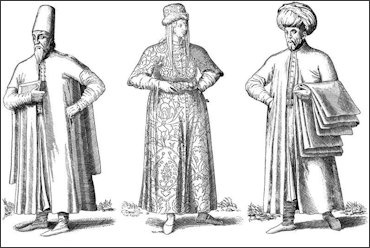
The word millet comes from the Arabic word for nation, milla, but in the Ottoman Empire it came to mean a religious community, specifically, non-Muslim religious minorities represented within the empire by an official political leader. Official Ottoman correspondence dealing with the non-Muslims of the empire in the early 19th century consistently affirmed that nonMuslims were organized into three officially sanctioned millets: Greek Orthodox, headed by the ecumenical patriarch, Armenians, headed by the Armenian patriarch of Istanbul, and Jews, who after 1835 were headed by the hahambaşı in Istanbul. The bureaucrats further asserted that this had been the tradition since the reign of Sultan Mehmed I (r. 1413–21). The millets as constituted in the 19th century were hierarchically organized religious bodies with a decidedly political function. Each was headed by a cleric (patriarch or chief rabbi, known in Ottoman Turkish as the millet başı) who was appointed by the sultan, usually from a list of candidates provided by the community’s leaders, and resident in Istanbul. But beyond that, the millet başı was largely free to order the affairs of his community as long as he remained loyal to the sultan. More importantly, as an officially sanctioned bureaucracy, the millet’s leadership could command the civil forces of empire, such as governors and kadıs, to implement its will over an errant flock.
Many historians have accepted the 19th century bureaucrats’ claim at face value and have asserted that the millet system as it existed in the 19th century had been a part of Ottoman rule since the 15th century. Recent scholarship has shown it was, in fact, a relatively recent Ottoman political innovation, even if its workings were always cloaked in the rhetoric of an ageless tradition. By the late 18th century, the Ottoman authorities were consistently intervening in disputes within and among the religious communities to support the established religious hierarchies against internal dissent. This was especially true within the Christian communities where there was conflict between Catholic and Orthodox Christian factions that eventually split every Christian millet into two competing bodies. Unlike the Christian churches, the Jews of the empire did not have a pre-existing clerical hierarchy. In the place of patriarchs and bishops, their religious communities functioned autonomously in each of the Ottoman cities they inhabited. Although the Jews were recognized as a separate religious community by both Muslim legal scholars and Ottoman officials, the Jews did not seek formal status as a millet until 1835 when the Ottoman government, in its attempt to standardize the way it dealt with each of the minority religious communities, pushed the Jewish community leaders to name a chief rabbi (hahambaşı) for the empire.
After the start of the Greek War of Independence in 1821, the prestige of the Orthodox ecumenical patriarch in Istanbul plummeted and the special relationship that had existed between the Greek Orthodox Church and the sultan ended. Faced with pressure from the European Catholic powers, notably France and Austria, the Ottomans recognized the Catholics as a millet in 1830. Later, that millet would only include the Armenian Catholic community, as the various other Uniate communities (those Christian sects that recognized the Roman Catholic pope as their spiritual head) pressed for recognition on their own behalf. By the end of the empire, the Ottoman officials recognized 12 separate Christian communities as millets.
During the Tanzimat reform period of the mid19th century, the Ottoman government pushed the millets to reform their internal governance, including school systems directed independently within each community. Reform was usually resisted by the clergy and advanced by the laity as a way of wresting some political authority away from the clerics. In 1863 the Armenians were the first community to write their own constitution governing the internal laws of their millet. This constitution transferred much of the community’s governance to an elected body of laity and clergy. The Orthodox and Jewish communities soon followed, although their experimentation was much less democratic than that of the Armenians. Some historians have seen this trend in local governance among the various religious communities as contributing to the rise of nationalist sentiments among the various Christian communities where religion and nationality could be conflated. The children of the communities were educated separately from Muslims and primarily in the language of their community. They were also taught the separate history of their community and its culture. It is this separate education that many believe inspired these groups to see themselves as separate peoples.
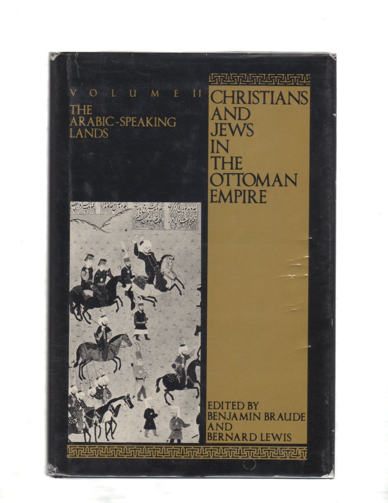
Benjamin Braude and Bernard Lewis, eds., Christians and Jews in the Ottoman Empire, 2 vols
Modern Turkey was born out of the Ottoman Empire after WW1. In 1939, Turkey signed a Mutual Aid Pact with France and the United Kingdom, but, avoiding to go directly into combat and fearing the Soviet Union (which had just jointly invaded Poland with Germany), Turkey along with the rest of the Balkan Entente (Romania, Yugoslavia, Greece, and Turkey) declared neutrality when France was invaded in 1940. In Jun 1941, as the German forces entered the Balkan Peninsula, Turkey and Germany signed a non-aggression pact; this pact gave Turkey the security it sought, while giving Germany the comfort of a safe flank as it planned to turn against the Soviet Union. Despite Turkish neutrality, the country did suffer some casualties during the war. On 3 Nov 1941, for example, Turkish schooner Kaynakdere was sunk by Soviet submarine ShCh-214 in the Black Sea as the Turkish schooner ventured near ground sheld by German troops (the Soviet submarine captain suspected that the schooner was smuggling in supplies for the Germans); Soviet submarines would sink several more Turkish vessels during the war. Turkey would suffer losses at the hands of the Axis as well, such as the loss of merchant ship Antares to Italian submarine Alagi in Jul 1942. Meanwhile, the Western Allies actively courted Turkey. In Dec 1941, days prior to the Pearl Harbor attack that brought the United States into the war, Franklin Roosevelt announced that Turkey was eligible to receive Lend-Lease aid. As the tide turned against Germany, Turkey leaned more and more toward the Allied side. Turkey halted the export of chromite, a key ingredient in the manufacture of stainless steel, to Germany in Apr 1944. On 2 Aug 1944, Turkey severed diplomatic relations with Germany. In Feb 1945, Turkey allowed itself to be courted by the Allies by attending the inaugural meeting of the United Nations, leading to a declaration of war on Germany on 23 Feb 1945. Turkish troops were not sent into combat, however.
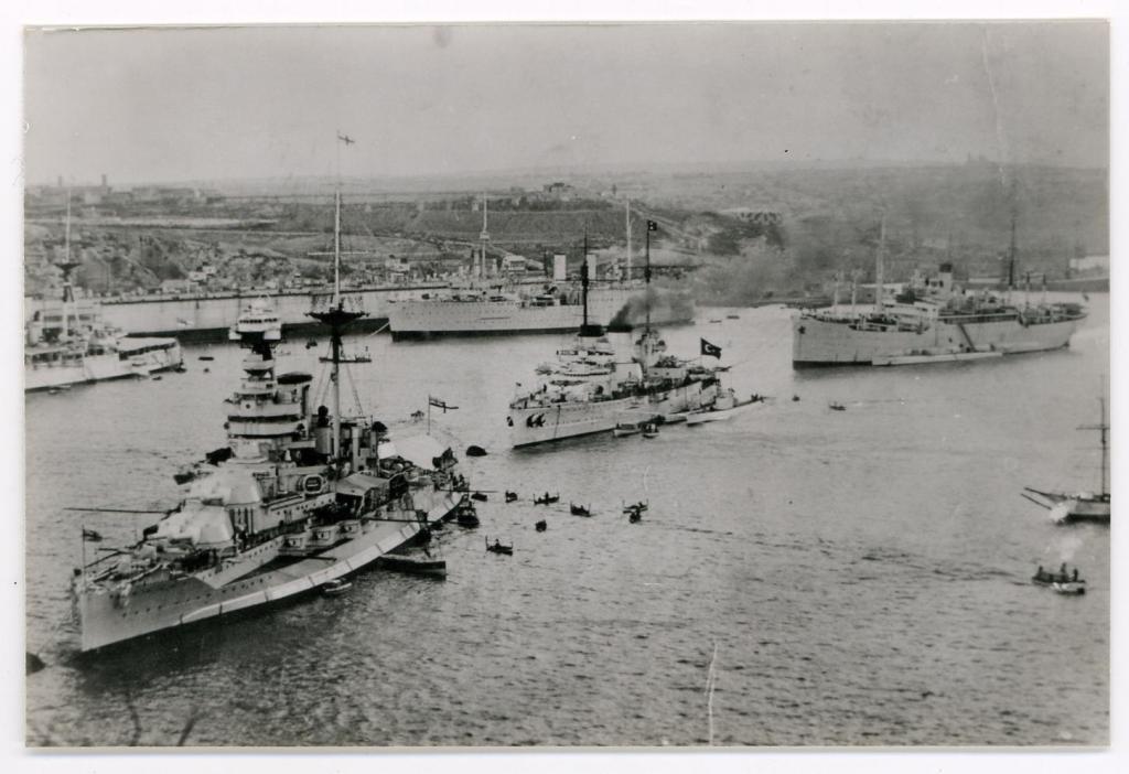
The Turkish fleet in Malta, in 1936, prior to World War II. The Navy was the weakest of the three armed services at the outbreak of war.
The Turkish Navy was the weakest of the services. It consisted of the outdated battle cruiser Yavuz (ex-Goeben), 4 destroyers, 5-6 submarines, 2 light cruisers, 3 mine-sweepers, 2 gunboats, 3 motor torpedo boats, 4 minelayers and a surveying vessel. The personnel strength was approximately 800 officers and 4,000 men. The Navy lacked all modern appliances for defending coasts and harbours, and the ships were defenceless against air attacks.
During the Anglo-Turkish Treaty negotiations in September 1939 a military credit agreement amounting to £25 million was agreed upon. A Turkish Ministry of Defence letter to the Turkish General Staff dating 22.03.1940 stated that the Turkish Army was to be increased to 1.3 million effectives forming 14 army corps consisting of 41 infantry and 3 cavalry divisions, 7 fortified positions and one armoured brigade. Yet, the letter stated, “the material resources of the nation were unable to provide for the provisioning and transport of this large number of effectives”.
Essential oils are primarily used in food and perfume production. Rose oil, a member of this group, is especially important in the cosmetic industry. Turkey and Bulgaria are the most important producers in the world. The rose flowers have produced for many years in Turkey. Most of them are grown as organic products and processing. In this study, we review the production, cultivation, trade and marketing of rose oil, with a primary focus on Turkey as a major producer. In addition, problems and proposed solutions relating to the rose oil business in Turkey are also presented.
Because of Turkey’s location and climate, many medical and aromatic plants are cultivated or obtained from the wild and many of these are specifically cultivated organically. Essential oils are obtained from plant flowers, leaves, fruit, seeds, stems and roots. There are many essential oil yielding plants grown in Turkey and the rose is among the most important and popular. In this study, we summarize Turkey’s rose oil production and marketing potential within the context of world rose oil market and review problems and present suggestions on how to improve Turkey’s rose oil production and marketing.
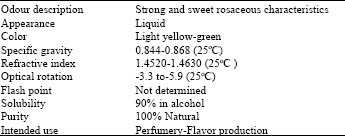
Characteristics and production of rose oil: Turkish Rosa damascena products can be grouped in four categories: Rose Oil, Rose Concrete, Rose Water and Rose Absolute. The physical and chemical characteristic of Turkish rose oil is as follows
produced by processing the rose flower. Roses are gathered in May-June when a 40-day flowering season occurs. Humidity and cloudiness during the season have an effect on the yield and quality of rose oil. The content of essential oil in the rose petals is poor- far below 1%. Because of the volatility of rose oil, content is the highest first thing in the morning when the flowers open; therefore, rose flowers used for distillation are picked manually, daily and before or at sunrise. Roses used for oil production are usually grown without using chemicals. There are two methods for rose oil distillation in Turkey: the traditional but slowly disappearing village-type distillations using long-fired crude copper still known as Imbeks and the modern factory production method using hydro-steam distillations called Kanas. The quality of rose oil produced by these two methods is same.
Characteristic components of rose oil are acyclic monoterpene alcohols, geraniol (up to 75%), citronellol (20%) and nerol (20%) and long-chain hydrocarbons like nonadecane or heneicosane (up to 10%).
An important trace component of rose oil is β-damascenone: Despite its low concentration (0.01%), C13-norisoprenoid has a notable influence on the quality of the oil; together with the structurally related compounds β-damascone and β-ionone, it is enzymatically generated from carotenoids. Similarly, in both saffron and pandanus leaves, the dominant aroma molecules derive from enzymatic degradation of carotenoids.
Characteristic of the fresh flower’s odour is 2-phenyl ethanol, which, though lost during steam distillation, accumulates in the rose water. Rose oil is obtained from the flowers of the oil-bearing rose (Rosa damascena) through water distillation. Thus, rose oil and rose water do not equal each other exactly. Even in the best case, only 10 g of the essential oil are distilled from as much as 100 kg fresh rose flowers (0.01%).
The most important rose oil producer countries are Turkey and Bulgaria. Combined, these two countries produce 80% of total rose oil supply. In 2001, world-wide rose oil production was 4.5 tons and 2-2.5 tons of this were from Turkey. Bulgaria produced 1.5 tons of the world wide total and an additional ton was supplied by Morocco, Iran and Mexico combined.
World rose oil annual consumption is much lower than the combined annual production total; in fact, yearly consumption is between 3.5 and 4.0 tons. This causes rose oil producer companies to carry product (stock) over from year to year. As a result, fluctuations in prices are encountered, with the severity of these fluctuations dependent on how aggressively companies compete for business and find additional customers for their products.
Gulbirlik, the successful Turkish rose market cooperative, determines rose oil pricing for Turkey’s private sector. The export price of rose oil is the main factor in determining the flower price. The flower’s share of total price of rose oil is 55%. It is reported that the total cost for rose flower production is 52.3% for labor, 17.7% for machinery, 12.8% for materials, 11.8% for field rent and 5.5% for draft animal power in Turkey.
Turkey is one of the leading rose flower producing countries, surpassed only by Bulgaria. For over 100 years, roses have mainly been grown in Turkey in Isparta county, in the Southwest part of Anatolia. Roses are also grown in some other parts of Turkey such as Afyon, Burdur and Denizli district. The production of oil rose (Rosa damascena) started in Isparta in 1888 and the first commercial production of rose oil was accomplished in 1892. In addition the first modern plant for rose oil production was build (established) as cooperative in 1953.
Currently, approximately 2-2.5 tons of rose and 4-4.5 tons of rose concrete are annually produced in Turkey. 8.200 families grow oil roses and 0.5-1.0% of total cultivated land in Turkey is used for rose production.
On average, 1 kg of rose oil is extracted from 3 to 5 tons of rose flower leaf. Rose oil is stream distilled from Rosa damascena flowers and rose oils, extracts and derivates are among the most important natural perfume ingredients[5]. These have remarkable diffusive power and are used in many types of perfume bases, blending particularly well with other floras. Rose oil is very expensive oil[3]. In fact, the price of the rose oil has averaged between 3.800 and 4.000 $ kg-1 and its highest price was 4.200 $ kg-1. The short flowering time of the Rosa damascena is a key reason for its high price[10]. There is competition between Turkey and Bulgaria for this market. Earlier maturation in Bulgaria[11,12] leads oil producers to prefer Bulgaria and this affects world rose oil price fluctuations.
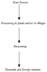
In plants with modern techniques 96.92% of rose flowers is processed[8]. The rose oil produced is mostly exported to foreign countries especially in the EU. This is one of the main reasons for an inadequate cosmetic industry in Turkey (Fig. 1).
Fig. 1: The processing and marketing system of rose oil in Turkey
Export of essential oils and rose oil in the world and Turkey: Based on the 2001 values, the essential oil world-wide export and import markets realized 7.3 and 5.5 billion $, respectively. Difference between these two values were caused by the re-export of different derivatives of essential oils and exports in the last months of any year taking the place of import values in the next year. Sometimes, transportation takes a few months. Consequently, this results in significant differences between the product and monetary amount. It is possible to follow a similar situation between FOB prices in export and CIF prices in import and also in the monetary values of exports and imports. The monetary values of essential oil trade in the world are shown in Table 1.
The EU countries, plus the USA and Japan, are the main importers of essential oils, accounting for 80% of total imports. Turkey’s worldwide essential oil export trade reached 8.6 million $ in 2000, 9 million $ in 2001 and 11.6 million $ in 2002 year. In addition, the import value was 3.3 million $ in 2000 and 2001 and reached 5.6 million $ in 2002[13].
Turkey’s share of the world essential oil trade has been as low as 0.16% with a value of 11.6 million $; but her rose oil export share is a much higher 40-45%.
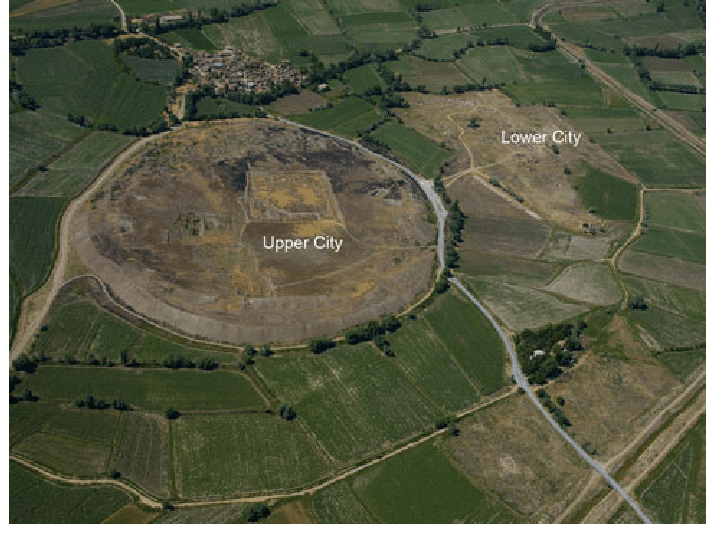
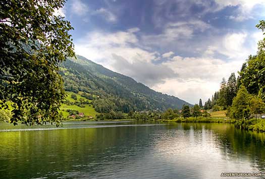
This large settlement mound (höyük), originally named Karahöyük in common with many other ancient mounds in Turkey, lies 20 kilometers northeast of the city of Kayseri (Roman Caesarea) in Cappadocia, a short distance southeast of the Kızıl Irmak (Red River), in Hittite times Marrassantiya and in Greco-Roman times Halys. One of the most important excavated sites in Anatolia, Kültepe is of special relevance for this dictionary, owing to its certain identification as the city of Nesa, which in its turn can be equated with Kanes, after Kussara, the first center of Hittite political and military power on the Anatolian plateau. Excavated since 1948 by an expedition directed by Tahsin Özgüç, of the University of Ankara, and sponsored by the Turkish Historical Foundation, it had been the site of earlier excavations between World Wars I and II under Bedrich Hrozny of Prague.
As happens all too often in the Near East, it was through the appearance of antiquities in the markets of Constantinople (Istanbul) and further afield, as well as locally, that scholarly attention was first drawn to south central Anatolia, Cappadocia in GrecoRoman times. Both inscribed clay tablets and distinctive painted pottery surfaced in considerable quantities, some 3,000 tablets in all, both categories being described as “Cappadocian.” This Cappadocian ware is now commonly termed Alışar III ware, having been found in that excavated mound in stratified context. This pottery and these tablets have found their way into a number of museums and private collections around the world, unlike the material from the official excavations at Kültepe, now displayed in Ankara and among the major attractions of the museum. Hrozny, a brilliant philologist, had been led to believe that this was the source of the Cappadocian tablets, though as a field archaeologist he found himself out of his depth. During his campaign of excavations at Kültepe (“ash mound”) he eventually unearthed some 600 tablets, among them finding references which proved he had located the ancient city of Kanes, whose full importance was not yet realized.
It was, however, some time before he stumbled upon the major feature of this large site, the presence at the foot of the main mound of an extensive low platform, not immediately recognizable as an outer, lower area of the town. He might not have located it when he did, had it not been for a disgruntled villager who came to Hrozny and divulged the secret of the area whence his fellow villagers were extracting clay tablets for sale in the markets. This was to prove to be the site of the greatest Old Assyrian trading community (karum), from which some 15,000 tablets and innumerable other finds have subsequently been recovered by the Turkish expedition.
There is a very long sequence of occupation levels in the main mound, or citadel, of Kültepe, from the Chalcolithic period (fourth millennium BC) down into the Iron Age (first millennium BC). For our purposes the strata from the later Early Bronze Age till the end of the Late Bronze Age are especially significant, the Iron Age also being not without interest. It is apparent that the karum of Kanes was first built and inhabited before the arrival of the Assyrian merchants and the organization of the Old Assyrian trade, for the earliest levels (Karum IVIII) are completely devoid of clay tablets. One theory is that tablets of wood, mentioned in later Hittite texts, may have been in use: if so, this would tend to add weight to the suggestion of an Anatolian, more specifically Luwian, presence here. But without further evidence this remains a matter of enlightened guesswork.
The city of Kültepe-Kanes, contemporary with Level II of the karum and thus dating ca.20501950 BC or a little later, was protected by two defensive lines, the inner wall being built on large unhewn stones, reused in the later defenses of Kanes IB attributable to Anitta, son of Pithana. Among the buildings excavated in the city is a likely palace, with residential quarters and a large paved open square. A palace and five temples are mentioned in the tablets. The entire city and the karum outside the walls were burnt in a violent destruction, conceivably the result of a Hittite attack, although Anitta’s association with Kanes IB and the intervening phase of Kanes IC make it chronologically unlikely to have been attributable to Pithana. The stratigraphy of the city, however, does not indicate any desertion of the site between Kanes II and IB, in spite of the destruction of Kanes II. The palace containing tablets of Warsama, king of Kanes, however, most probably belongs to a phase (IC) when the karum was abandoned, and the merchants had withdrawn within the walls of the Anatolian city, if they had not indeed retreated to Assur. A bronze spearhead with typically Anatolian bent tang bearing the inscription “Palace of Anitta the king” was recovered from a public building within the city in Kanes IB context, adding weight to the claims made in the Anitta Text. In the karum of Kanes the orientation of streets and many buildings remained essentially the same from Level II through IB IA. The buildings all have andesite footings up to floor level only, with mud-brick walls above, though the stonework was in some places carried higher, as behind kitchen ovens. The whole character of the buildings was Anatolian, with no trace of influence from Assyria, the houses being plastered and whitewashed. There is no evidence of gabled roofs. Details such as door jambs, charred remains of wooden door frames and pivot stones demonstrate the access to buildings. Stone paving was used where water was much in use. The majority of houses in Level II of the karum either have two rooms and a rectangular plan or two rooms opening on to a large main room or many rooms off a corridor. Houses were extended as required, presumably with the growth of the household, often with walls set at irregular angles. The population was evidently increasing. Five districts have been identified in the areas occupied by the merchants’ houses, with varying yields of tablets, while other houses excavated 1.5 kilometers to the south contained none.
The significance of this can only be surmised. The makeup of the population of each district can be estimated from its tablets. Most of the Assyrians lived in the first and second districts, being in the majority in the third and fifth districts, alongside native Anatolian merchants. Only the fourth district was perhaps exclusively Anatolian, and the native houses yielded notably fewer tablets. The major archives were housed in the north, northeast and central areas of the karum.
Another area was devoted to workshops and supporting services in the southeast part of the karum, where native householders mostly dwelt. Workshops occur in widely separated parts of the karum, not grouped all together, though no bit karim has been found, this being known only from the tablets. Much evidence remains to be uncovered in the form of more workshops as well as in the thousands of as yet unpublished tablets, which must include references to copper, gold and silver artifacts. Tools, weapons and decorative items of metal, stone and terracotta were manufactured by the craftsmen, no doubt following traditional practices dating back well before the arrival of the Assyrian merchants.
One workshop of the later period (IB) yielded portable and large fixed molds, crucibles, blow-pipes and pot-bellows, indicating metallurgy on an organized footing. It would be mistaken to suggest that it was solely owing to the arrival of the foreign traders from Assur that the level of sophistication in the economy of central Anatolia was attained. More probably a network of trade routes had evolved through the activities of native Anatolian merchants, with the Assyrian newcomers being adept at profiting from established business networks. Kanes had a long history of urban life, the growth of trade in Anatolia emerging during the Early Bronze III period, whose beginning in the midthird millennium BC could be said to mark a cultural watershed not repeated until the advent of the Iron Age in the 12th century BC.
The characteristic Alışar III (Cappadocian) ware appears at Kültepe in the levels termed Early and Middle Cappadocian, continuing through the Late Cappadocian phase, which includes the first two levels (IVIII) of the karum of Kanes. This painted pottery underwent three phases of development conforming with the sequence of levels at Kanes. It is noteworthy that it was in the Early Cappadocian phase, long before the arrival of Assyrian merchants, that the Anatolian city contained a public building of megaron plan, either a temple or a palace, suggesting western influence on central Anatolia. Could this have been an outcome of the Luwian migrations? The vicissitudes of Anatolian society, with growing conflicts between the various minor kingdoms perhaps in part stimulated by competition to enjoy the benefits accruing from the presence of foreign merchants able to pay tolls to allow safe passage of their caravans, had driven the Assyrian inhabitants of the karum of Kanes away.
The perimeter wall surrounding the karum of Kanes IB suggests the necessity of effective protection for the merchants returning to Kanes and in fact extending their trade to other merchant colonies. How much significance is to be attached to the smaller number of tablets found in karum IB compared with karum II is not entirely clear. What is evident is that the second period of Assyrian activity at Kanes lasted a shorter time, on the evidence of limmu names on the tablets, than the first period (karum II). After the first destruction the period of desertion of the karum (IC) probably lasted not less than 50 years, seeing that graves of this time dug into the ruins of karum II were evidently unknown to the inhabitants of the reoccupied colony (karum IB), not being robbed of their contents.
Though there are fewer tablets to reveal details of the Old Assyrian trade in the time of karum IB, it would be mistaken to conclude that this trade had shrunk in volume or variety. Two factors indicate the contrary: first, the expansion of the area of the ka- rum of Kanes to a diameter of over one kilometer, within a wall built on a footing of massive andesite blocks, at the same time as the native Anatolian city grew in size; second, the establishment of other trading posts or colonies, each a karum, at Alışar II, Boğazköy (Hattusa) and Acemhöyük (Burushattum).
The relative chronology of Kültepe-Kanes is greatly clarified by limmu names synchronizing Kültepe IB, Alışar II and Tell Chagar Bazar in the Khabur valley with the reign of Samsi-Adad I of Assyria (1813-1781 BC), overlapping with that of Hammurabi of Babylon (17921750 BC). The following absolute chronology for the successive periods of the karum of Kültepe-Kanes therefore seems plausible: Kültepe II, ca.2050/20001900 BC; Kültepe IC, ca.19001850 BC; Kültepe IB, ca.18501800 BC or slightly later; Kültepe IA, ending ca.1750 BC. The final phase of the karum (IA) was but a pale reflection of what had gone before. It was undoubtedly owing to growing unrest and insecurity for the caravans with discord among the Anatolian kingdoms, rather than any economic changes in Assyria, that the Old Assyrian trade finally came to an end. A brief dark age descended upon the Anatolian plateau, to be lifted a century later under Hattusili I. Never again, however, was such a sophisticated commercial network to flourish in the lands destined to come under Hittite rule. The state would step in where the great merchant family firms had once ruled.
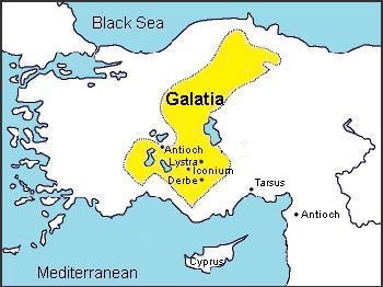
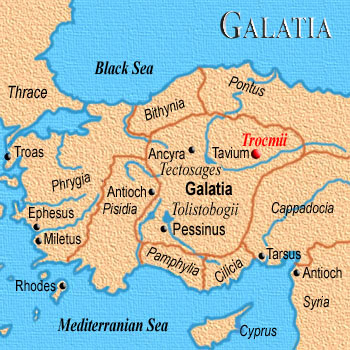
In the strict sense (Galatia Proper, Roman Gallograecia) this is the name applied by Greek-speaking peoples to a large inland district of Asia Minor since its occupation by Gaulish tribes in the 3rd century B.C. Bounded on the N. by Bithynia and Paphlagonia, W. by Phrygia, S. by Lycaonia and Cappadocia, E. by Pontus, it included the greater part of the modern vilayet of Angora, stretching from Pessinus eastwards to Tavium and from the Paphlagonian hills N. of Ancyra southwards to the N. end of the salt lake Tatta (but probably including the plains W. of the lake during the greater part of its history), – a rough oblong about 200 m. long and ioo (to 130) broad.
To designate a large province of the Roman empire, including not merely the country Galatia, but also Paphlagonia and parts of Pontus, Phrygia, Pisidia, Lycaonia and Isauria. The name occurs in 1 Corinthians 16:1 Galatians 1:2 1 Peter 1:1, and perhaps 2 Timothy 4:10. Some writers assume that Galatia is also mentioned in Acts 16:6; Acts 18:23; but the Greek there has the phrase “Galatic region” or “territory,” though the English Versions of the Bible has “Galatia”; and it must not be assumed without proof that “Galatic region” is synonymous with “Galatia.” If e.g. a modern narrative mentioned that a traveler crossed British territory, we know that this means something quite different from crossing Britain. “Galatic region” has a different connotation from “Galatia”; and, even if we should find that geographically it was equivalent, the writer had some reason for using that special form.
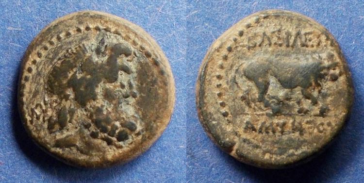
8.88g Laureate head of Zeus right Lion walking right “BASILEWS AMYNTOY” SNG Von Aulock 6106 (same dies) Rare type with Zeus instead of Herakles on the obverse
Given the consonant shift proposed for the Belgae, then ‘Belgae’ would indicate that its ‘b’ replaced an older (?) form of a ‘w’ sound. This supplies ‘Welgae’ as a possible older form of Belgae, and rather astonishingly that ‘wel-‘ sounds incredibly similar to what the Germans call Celts! So the possibility is raised that the original ethnic name was ‘Wel’, and while the Belgae were in northern central Europe this mutated into ‘vel’ and then ‘bel’; while in the west and south the ‘w’ of ‘wel’ acquired a hard ‘k’ or ‘g’ in front of it, to form ‘kwel’ or ‘gwel’, therefore giving rise to words such as ‘celtae’ and ‘galati’. Curiously, a Belgic origin is often claimed for the Galatian Celts. Given the marked Belgic features found in names for the Taurisci and Scordisci, could the entire Balkans settlement by Celts have been of a Belgic origin? Ritual death practices by the Galatians also appears to provide backup for this.
The Tolistoboges (or Tolostobogi), who seem to have been entirely anonymous before the migration, were said by Strabo to have taken their name from their leaders. This indicates a mixed group from several tribes that needed to find its own identity, which explains the tribe’s previous anonymity. Other sources claim the Tolistoboges as the Tolistoboii, a division of the greater Boii. The ‘g’ in ‘boges’ is pronounced as a ‘gh’, a guttural ‘h’. So the tribe would be Tolisto-boii (‘bo-hee’ with a strong ‘h’), thereby supporting both versions of the name – it’s simply down to pronunciation. As far as breaking down the name goes, ‘tolisto-‘ is probably a man’s name, a leader named Tolistos or Tolistorix (a ‘King Tolistos’, possibly the father or grandfather of Brennus?). The proto-Celtic word list has ‘listo’ defined as a nickname without any further explanation, but another section indicates that it might mean an adopted or fostered relative: *(φ?)listo-makʷ(kʷ)o- (?), meaning ‘stepson’. The initial ‘to-‘ is probably the pronoun, ‘you’. The tribe were the ‘Boii of Tolistos’, thereby affirming their link to this large collective.
The Trocmes (or Trocmi, Trogmi) were equally unknown before their migration. Trogmi or Trocmi appears to have some very strange possibilities when it comes to breaking it down. On the one hand it might derive from ‘trougos’, meaning ‘misery’. Or it is more likely to be ‘trokkos’, meaning ‘to bathe’. The ‘m-‘ on the end appears to be a personal pronoun, ‘me’ or ‘mi’. So the most likely meaning is ‘I bathe’, which is good to know! The alternative may mean ‘I am miserable’ or something similar – hardly an inspiring tribal name.
Pliny the Elder mentions the Ambitouti and Voturi, apparently as divisions of the Tolistoboges. The Ambitouti name can be broken into two parts, staring with an old friend, ‘ambi-‘, meaning on both sides, or providing an extended meaning of universally, which is also used by tribes such as the Ambarri, Ambidravi, and Ambisontes. The second part of the name, ‘touti’, means the ‘tribe or folk’. They were probably ‘all of the people’, possibly in the same sense as the Celtic ‘combrogi’, meaning ‘people of the same land’ or more specifically ‘brothers-in-arms, compatriots’, which was used by the Sicambri and others. As for the Voturi, the closest option in proto-Celtic seems to be *wor-tero- < *wer-tero-, meaning ‘noble’. They were ‘the nobles’ or similar.
The Teutobodiaci are another apparent splinter group that is mentioned by Pliny the Elder. Breaking it down, ‘teuto’ is ‘people or tribe’, while ‘bodiaci’ appears to be the name Boudicca (which was also used by the famous queen of the Insular Iceni). The female form is Boudicca, while the male form is Boudiccos. The were ‘the people of Boudiccos’, possibly one of their founding tetrarchs.
The Arecomisci tribe settled a wide swathe of what is now south-eastern France, occupying the entire central and western parts of the later Roman province of Narbonensis. They appear to have been a branch of the widely-travelled Volcae collective, some of which, elements of the Volcae Tectosages, moved to Anatolia. Once there, they and the other Gauls formed capitals for each of their various divisions. The Tectosages were centred on Ancyra (modern Ankara, the Turkish capital). The Tolistoboges located themselves at ancient Gordion (resting place of, arguably, Gordios III of Phrygia). The Trocmes based themselves at Tauion (Tavium, location uncertain). They organised a system of four ‘tetrarchies’ to each tribe, each of which sent twenty-five representatives to a great council that would handle matters of national importance. The heavily-Hellenicised descendants of these tribes formed a kingdom in the first century BC which quickly became a Roman client state.
(Information by Peter Kessler and Edward Dawson, with additional information from The La Tene Celtic Belgae Tribes in England: Y-Chromosome Haplogroup R-U152 – Hypothesis C, David K Faux, from Commentarii in Epistulam ad Galatas II, 3 = Patrologia Latina 26, 357, St Jerome, from Guide for Greece, Pausanias, and from External Links: Journal of Celtic Studies in Eastern Europe and Asia-Minor, and The Works of Julius Caesar: Gallic Wars, and Geography, Strabo (H C Hamilton & W Falconer, London, 1903, Perseus Online Edition).)
The questions that have to be answered are: (a) In which of the two senses is “Galatia” used by Paul and Peter? (b) What did Luke mean by Galatic region or territory? These questions have not merely geographical import; they bear most closely, and exercise determining influence, on many points in the biography, chronology, missionary work and methods of Paul.
The name was introduced into Asia after 278-277 B.C., when a large body of migrating Gauls (Galatai in Greek) crossed over from Europe at the invitation of Nikomedes, king of Bithynia; after ravaging a great part of Western Asia Minor they were gradually confined to a district, and boundaries were fixed for them after 232 B.C. Thus, originated the independent state of Galatia, inhabited by three Gaulish tribes, Tolistobogioi, Tektosages and Trokmoi, with three city-centers, Pessinus, Ankyra and Tavia (Tavion in Strabo), who had brought their wives and families with them, and therefore continued to be a distinct Gaulish race and stock (which would have been impossible if they had come as simple warriors who took wives from the conquered inhabitants). The Gaulish language was apparently imposed on all the old inhabitants, who remained in the country as an inferior caste. The Galatai soon adopted the country religion, alongside of their own; the latter they retained at least as late as the 2nd century after Christ, but it was politically important for them to maintain and exercise the powers of the old priesthood, as at Pessinus, where the Galatai shared the office with the old priestly families.
c.300 BC The last stages of Hallstatt culture sees Celts involved in a great expansion into southern and eastern Europe. Tribes infiltrate across the Danube to enter the land on the southern edge of the Eastern Alps, in the form of the Latovici, Serapili, Sereti, and Taurisci. The native communities in the hinterland of the Adriatic between Carinthia and Carniola are relatively rapidly assimilated by the Celtic newcomers, soon losing their identity completely. The migration turns into a powerful juggernaut as it enters the Balkans to come up against the Thracian and Greek kingdoms. It is unclear whether later La Tène elements of Celtic culture are also involved, but it is entirely possible.
The modern southern Austrian region of Carinthia marked the upper edge of the Adriatic hinterland which was first occupied by Celts towards the end of the fourth century BC, and it is from these early arrivals that the Galatians and Scordisci seem to have sprung
c.282 – 281 BC
Gauls who are settled in Pannonia begin a series of campaigns southwards towards Thrace under the leadership of Cambaules. The first two campaigns see Cambaules and his leading veterans divide their followers, sending one part against the Thracians and Triballi under Cerethrius, a second against Paeonia under Brennus and Acichorius, and a third against the Macedonians and Illyrians under Bolgios.
279 BC Despite ruling both the Lysimachian empire and Macedonia, and having his main rival, the Antigonid King Antigonus II Gonatas bottled up in his own capital, Ptolemy II Ceraunus is killed in the invasion of Greece by the contingent under Bolgios. The kingdom is plunged into anarchy as the Celts invade further into Greece, and only the Aetolians seem to be able to take the lead in defending Greek territory.
278 – 277 BC Brennus and Acichorius lead the third campaign by the Celts, although this is eventually defeated by a force led by the Aetolians. Following victory at Thermopylae, they advance to Delphi in 278 BC where they are routed by the Greek army, and then suffer a crushing defeat (under Cerethrius) at the hands of the Antigonid King Antigonus II in 277 BC. With Brennus dead, they retreat from Greece and pass through Thrace to enter into Asia Minor, although a small contingent (around 20,00 people, half of whom are warriors) under the leadership of Liutarius and Leonnarius already seems to have made the journey in 278 BC, with the rest merely following a now-established route in their wake. These Celts in Anatolia (centred on lands that are taken from Antigonid Phrygia) form tribal regions that are based around each of the three main constituents of the confederation. The Tectosages base themselves at Ancyra (modern Ankara, with their leaders shown below in black), while the Tolistoboges settle at Gordion (to the west of Ankara, shown in green), and the Trocmes concentrate themselves at Tauion (shown in red), all in Anatolia. A separate kingdom is established in Thrace, at the city of Tilis (shown in light grey).
The Gauls moved into an Anatolian landscape that was littered with remnants of previous kingdoms, notably that of Arzawa, which formerly dominated the Phrygian lands
The far larger remnant of Gauls who remain in the Balkans join together to form a confederation that finally settles at the junction of the rivers Savus and Danube in the Balkans. They adopt a name which highlights their acceptance of this territory as their new home, taking the mountain’s name itself as the ‘people of the Scord’ – the Scordisci. They probably pick up elements of many of the local peoples along the way, Dacians, Illyrians, and Thracians. From there they raid into Macedonia, weakening the kingdom and later forcing a good many of the Roman governors there to campaign against them during the late second and early first centuries BC.
278 – ? BC Liutarius
278 – ? BC Leonnarius
c.278 BC Outside of Anatolia, the westernmost portion of Galatia is the Celtic kingdom that is established at Tilis (or Tylis, Tyle). This city in eastern Thrace and its Celtic occupiers are both mentioned by Polybius in relation to Commontorios setting up his own kingdom in the wake of the Celtic rampage through the Balkans. The city of Tilis is located near the eastern edge of the Haemus (Balkan) Mountains in what is now eastern Bulgaria (the modern Bulgarian village of Tulovo in Stara Zagora province now occupies the site).
c.278 – c.250 BC Commontorios / Kommotorios
275 BC The Galatians seem to be expanding the territory they command, presenting a growing threat to the eastern kingdoms in Anatolia. The Seleucid king in Syria, Antiochus I, attacks the Galatians from the east. Defeating them at the Battle of the Elephants, he pushes back their borders and, allegedly, gains the title ‘soter’ (meaning ‘saviour’) thanks to his victory.
273 BC The Celts invade Thrace again, destroying the Thracian kingdom and forcing the Greek aristocracy to escape to the colonies bordering the Black Sea. The kingdom of Galatia now covers territory from the lower Balkans to Anatolia. Its victorious creators settle down to life that is fairly traditional, although they have adopted an internal organisation that is much enhanced, with separate judges and military commanders who are all subject to the regional tetrarch. Some Celts at least learn to read Greek, although whether any records are kept by the Celts themselves in any language, Greek or otherwise, is doubtful.
230 BC The city of Pergamum has been ruled as an Hellenic domain of the Lysimachian empire (during the lifetime of Satrap Philetaerus), with the city being turned into a fortress to house many of the Lysimachian riches. It is only with the success now of Attalus against the Galatian Celts that an independent kingdom is proclaimed in 230 BC, although it still remains within Greece’s sphere of influence.
? – c.218 BC Kavaros
214 BC The Thracians eject the Celtic kingdom of Galatia from Greece and fully restore Thracian rule. Only the Celtic kingdom at Tilis in eastern Thrace remains in Celtic hands. The early Galatian kingdom (or rather, confederation) has over-extended itself by claiming too much territory. Now it faces pressure from east and west and its borders contract.
212 BC The Celtic kingdom that is based at the city of Tilis (or Tylis) in eastern Thrace is attacked by Pleuratus, would-be king of Thrace who may reign in opposition to the already-established Seuthes IV. The kingdom is apparently destroyed by the action, as is the city itself.
c.200 BC By now Galatia has been settled for almost a century around the River Halys and the Phrygian plain – the poorest parts of Anatolia. According to Pliny the Elder, it lies ‘above’ Phrygia and includes the greater part of the territory taken from that province, along with its former capital at Gordion (Gordium). The Gauls of these parts are called the Tolistobogi (Tolistoboges), the Voturi and the Ambitouti. The latter seem to be divisions of the Tolistoboges, never apparently having been mentioned in history at any time prior to this appearance.
The Gauls of Maeonia and Paphlagonia are called the Trocmi (Trocmes). Cappadocia stretches along to the north-west of Galatia, with its most fertile regions being in the possession of the Tectosages and Teutobodiaci. The latter is another new group, or division, presumably from the main host of Tectosages.
Transference to Rome:
The Galatian state of the Three Tribes lasted till 25 B.C., governed first by a council and by tetrarchs, or chiefs of the twelve divisions (four to each tribe) of the people, then, after 63 B.C., by three kings. Of these, Deiotaros succeeded in establishing himself as sole king, by murdering the two other tribal kings; and after his death in 40 B.C. his power passed to Castor and then to Amyntas, 36-25 B.C. Amyntas bequeathed his kingdom to Rome; and it was made a Roman province (Dion Cass. 48, 33, 5; Strabo, 567, omits Castor). Amyntas had ruled also parts of Phrygia, Pisidia, Lycaonia and Isauria. The new province included these parts, and to it were added Paphlagonia 6 B.C., part of Pontus 2 B.C. (called Pontus Galaticus in distinction from Eastern Pontus, which was governed by King Polemon and styled Polemoniacus), and in 64 also Pontus Polemoniacus. Part of Lycaonia was non-Roman and was governed by King Antiochus; from 41 to 72 A.D. Laranda belonged to this district, which was distinguished as Antiochiana regio from the Roman region Lycaonia called Galatica.
The Roman Province:
This large province was divided into regiones for administrative purposes; and the regiones coincided roughly with the old national divisions Pisidia, Phrygia (including Antioch, Iconium, Apollonia), Lycaonia (including Derbe, Lystra and a district organized on the village-system), etc. See Calder in Journal of Roman Studies, 1912. This province was called by the Romans Galatia, as being the kingdom of Amyntas (just like the province Asia, which also consisted of a number of different countries as diverse and alien as those of province Galatia, and was so called because the Romans popularly and loosely spoke of the kings of that congeries of countries as kings of Asia). The extent of both names, Asia and Galatia, in Roman language, varied with the varying bounds of each province. The name “Galatia” is used to indicate the province, as it was at the moment, by Ptolemy, Pliny v.146, Tacitus Hist. ii0.9; Ann. xiii. 35; later chroniclers, Syncellus, Eutropius, and Hist. Aug. Max. et Balb. 7 (who derived it from earlier authorities, and used it in the old sense, not the sense customary in their own time); and in inscriptions CIL, III, 254, 272 (Eph. Ep. v.51); VI, 1408, 1409, 332; VIII, 11028 (Mommsen rightly, not Schmidt), 18270, etc. It will be observed that these are almost all Roman sources, and (as we shall see) express a purely Roman view. If Paul used the name “Galatia” to indicate the province, this would show that he consistently and naturally took a Roman view, used names in a Roman connotation, and grouped his churches according to Roman provincial divisions; but that is characteristic of the apostle, who looked forward from Asia to Rome (Acts 19:21), aimed at imperial conquest and marched across the Empire from province to province (Macedonia, Achaia, Asia are always provinces to Paul). On the other hand, in the East and the Greco-Asiatic world, the tendency was to speak of the province either as the Galatic Eparchia (as at Iconium in 54 A.D., CIG, 3991), or by enumeration of its regiones (or a selection of the regiones). The latter method is followed in a number of inscriptions found in the province (CIL, III, passim). Now let us apply these contemporary facts to the interpretation of the narrative of Luke.
III. The Narrative of Luke.
Stages of Evangelization of Province:
The evangelization of the province began in Acts 13:14. The stages are:
(1) the audience in the synagogue, Acts 13:42;
(2) almost the whole city, 13:44;
(3) the whole region, i.e. a large district which was affected from the capital (as the whole of Asia was affected from Ephesus 19:10);
(4) Iconium another city of this region: in 13:51 no boundary is mentioned;
(5) a new region Lycaonia with two cities and surrounding district (14:6);
(6) return journey to organize the churches in (a) Lystra, (b) Iconium and Antioch (the secondary
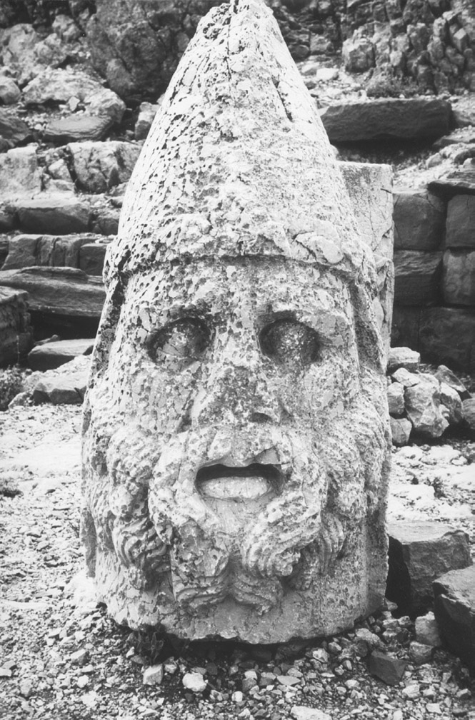
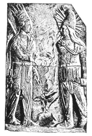
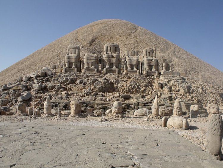
Mount Nemrut – West Terrace: Head of Goddess of Kommagene (Tyche, goddess of luck, fortune and prosperity) Nemrut Tümülüsü Gods of Commagene KING ANTIOCHUS AND MITHRA. Bas-relief of the temple built by Antiochus I of Commagene, 69-31 BCE, on the Nemrood Dagh, in the Taurus Mountains
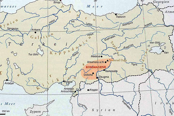
COMMAGENE, the portion of southwestern Asia Minor (modern Turkey) bordered on the east by the Euphrates river, on the west by the Taurus mountains, and on the south by the plains of northern Syria. It was part of the Achaemenid empire and its successor kingdoms and did not achieve status as an independent kingdom until the mid-2nd century B.C.E. Commagene is unique in that indigenous documentation is more extensive than the notices in Greek and Roman sources; nevertheless, that documentation, which consists of official inscriptions in Greek, is skewed: The royal monuments of Antiochus I (ca. 69-30s b.c.e.) predominate, and the inscriptions (identified here by letters, following Wagner, 1983; and Waldmann) reflect his claims for himself and his dynasty.
Commagene controlled Euphrates crossings from Mesopotamia and was thus the favored invasion route for Persian troops moving west (Cicero, Ad Familiares 8.10.1; Strabo, 16.746, 749; Appian, Syriaca 48; Dio Cassius, 49.13; Pliny, Naturalis Historia 5.86). The kingdom became wealthy from trade and agriculture, particularly on the fertile lands around the capital, Samosata (Strabo, 16.749; cf. 12.535 on fruit trees). Although the means by which the rulers of Commagene developed their land economically are not entirely clear, the existence of great wealth is obvious from the array of royal monuments, the number of festivals celebrated throughout the kingdom, invaders’ expectations of booty (Plutarch, Antony 34), and contemporary notices of royal wealth (Tacitus, Annales 2.81 ).
Political history. Under Achaemenid rule Commagene was administered by a minor official, stationed at Samosata or a similar site and responsible for protecting the Euphrates crossings. Antiochus claimed to be descended from Achaemenid royalty through Orontes, the noted satrap of Armenia in the 4th century b.c.e. (e.g.. Plutarch, Artoxerxes 27); this claim suggests that in the Achaemenid period Commagene may have been part of the satrapy of Armenia and that intermarriage among Persian and Persianized nobility was common in the region. During the Hellenistic period Commagene was part of the Seleucid empire and was at times subject to the nominally Seleucid dynasts of Armenia. Antiochus’ royal inscriptions at Arsameia on the Euphrates (modern Gerger; inscription G) and Arsameia on the Nymphaios (modern Eski Kahta; inscription A) include references to his ancestor Arsames, “founder” of both cities. This Arsames can be identified with the Arsames whom Polyaenus (4.17) described as an Armenian dynast supporting the rebel Seleucid Antiochus Hierax in the mid-3nd century b.c.e. Arsames fortified Arsameia on the Nymphaios as part of his building of a power base against the legitimate Seleucid king, Seleucus II Callinicus (246-26 b.c.e.).
The history of the kingdom of Commagene begins with the reign of Ptolemaeus, a Seleucid officer who became king in 163 or 162 b.c.e. Despite Antiochus’ grandiose claims, the royal family of Commagene was probably an indigenous and somewhat Hellenized dynasty, the early members of which had been assigned Greek titles in the Seleucid administrative hierarchy (e.g. Ptolemaeus Epistates; Diodorus Siculus, 31.19a). At first Commagene was a third-ranking power, weaker than the former Achaemenid satrapies of Armenia and Cappadocia, which were then in conflict over the region of Sophene (Diodorus Siculus, 31.22). Ptolemaeus took advantage of such strife to establish Commagene as a kingdom, which he immediately enlarged by occupying northern strong points in Melitene, part of Cappadocia. His successor, his son Samus, is known only from coins, on which he is represented in both Seleucid and Persian style, and from his grandson Antiochus’ monuments at Nimrud Dagh (inscription Nfa/Nfb = OGI 396 in part) and Arsameia on the Euphrates (inscription Gf = OGI 402).
The reigns of Mithradates I and Antiochus I are better documented. Commagene was clearly a minor power with a limited range of politic
Gaius Cassius LonginusRoman Empire During the Triumvarate
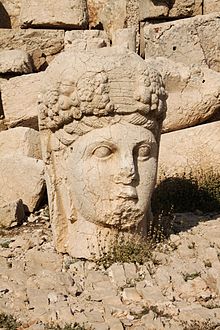
Monumental head from the tomb of Antiochus, first-century BCE ruler of Commagene, on Mt. Taurus in Turkey
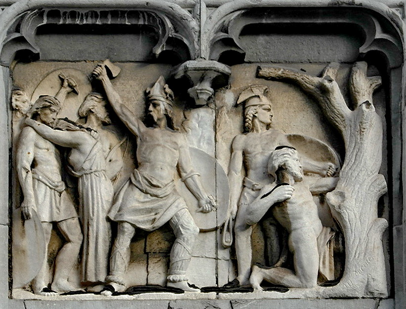
West façade of the provincial palace in Liège, Belgium Here a sculpted relief of the wars of Ambiorix against the Romans.
Though the events of 53 BC had seen the comprehensive failure of the Carrhae campaign, the First Romano-Parthian War was far from over. We must therefore look at the aftermath of the campaign and the other years of the war before we can draw any overall conclusions about this period of history.
Rome after Carrhae
For Roman power in the east, the disastrous Carrhae campaign had a number of effects. In the first place, the Roman province of Syria (a long term Parthian target) now lay virtually defenceless. The legions stationed there had been taken by Crassus on his invasion of Parthia and had died along with him. Thus the province of Syria had neither governor, nor garrison. All it did have was around 10,000 legionaries (from across the seven destroyed legions) who had made it back from Carrhae. In terms of officers, the most senior man in Roman Syria was Gaius Cassius Longinus, who only held the rank of pro-quaestor and whose military capabilities had been seriously called into question during the Carrhae campaign.
If this was not enough, then we need to consider the state of the Roman Empire in the east as a whole. The Pompeian settlement which had established Roman hegemony in the east was based on the power, image and threat of Rome, rather than a present physical force. The only territories that were Roman provinces were Asia, Bithynia & Pontus, Cilicia and Syria. Outside of Syria the only one of these with more than garrison strength was Cilicia, and that had less than 15,000 men stationed there. Most of the region was composed of client kingdoms who owed their allegiance to Rome due to a combination of past obligations and Rome’s overwhelming military superiority; and in matters of statecraft, past obligations tended to count for little. These kingdoms remained allied to Rome through the fear and respect that the Roman army had instilled in them. Thus the defeat at Carrhae had done more than simply cost the Romans a commander and his men; it had devastated their military reputation in the region at the expense of their neighbour and rival.
Of these client kingdoms, the greatest of them, Armenia, had already moved from the Roman sphere of influence back into the Parthian one. In the region of the northern Euphrates lay two minor client kingdoms: Osroene and Commagene. Abgarus, the ruler of Osroene, wasted no time in affirming his allegiance to Orodes and dismissing any talk of him aiding Crassus (as seen earlier) as being nothing more than a double bluff. He probably attempted to claim some of the credit for leading Crassus into defeat at Carrhae. The Kingdom of Commagene appears to have remained loyal to Rome in the short term, but could do little about the Parthians crossing the Euphrates and invading them, other than warn the Romans. Should the Parthians do so, then Commagene would have to swear allegiance to Orodes. Cappadocia had just gained a new young king, whose grip on the throne was tenuous at best and so was of little use to Rome and actually gave them another source of concern.261 This left the kingdom of Judea in the south, which had been a perpetual source of revolt for the Seleucids and had already twice required Roman intervention in the past decade (Pompey in 63 and Gabinius in 55). Given their past reputation and perpetual internal chaos, it is not surprising that when the news of the Roman defeat at Carrhae reached them, yet another anti-Roman insurrection broke out.Even within Syria itself, anti-Roman elements were agitating against the Romans. All in all, the situation that Rome faced in the east was grave. Leadership and decisive action would be needed by the Senate, and Rome’s two surviving triumvirs, if the situation was to be salvaged.
Unfortunately for the Romans in the east and the Republic as a whole, the Senate and Rome’s leading men were apparently too busy with domestic politics to bother about a catastrophic situation on the edges of their empire. For much of 53 BC the Republic was without formal government. It was not until July that consuls for that year were elected (rather than during the previous year). This situation was symptomatic of the chaos that had broken out in Rome. Following Crassus’ departure for the east, Caesar became bogged down in Gaul and an abortive invasion of Britain, leaving Pompey to manage affairs in Rome. Furthermore, a bribery scandal had broken out during the elections for the consuls of 53 BC, which resulted first in political deadlock and then outright chaos, as the elections were continually prevented from being held. Old political scores were being settled both in the courts (Gabinius was tried twice for his actions in Egypt and finally convicted) and ultimately on the streets, with Clodius and Milo both re-arming their gangs and bringing armed fighting onto Rome’s thoroughfares once more. Pompey had to absent himself from Rome to see if the chaos died down. By the time he returned and used his authority and political power to get the elections held for the consuls of 53 BC, attention immediately turned to the elections for the consuls of 52 BC, and thus the whole cycle of political chaos was sparked off once more. It was into this chaos that news of the disaster at Carrhae arrived.
It appears that few tears were shed by the Senate and people of Rome over the loss of Crassus. It also appears that both groups failed to appreciate the gravity of the situation in the east. As for Crassus’ former colleagues, Caesar was still fighting for his life suppressing rebellions that had broken out all over Gaul and even striking out across the Rhine to stabilise his new conquests, and Pompey was trying to hold the situation in Rome together and hoping to profit by it. Therefore neither man had time to worry about the eastern frontier.
In the midst of this turmoil we are unsure how the news of the disaster at Carrhae was received. It came on the heels of a reversal for Caesar in Gaul (a rebellion had broken out, which resulted in the loss of a legionary camp and a whole legion with it). Thus it was possible that Carrhae was seen as one disaster amongst many, which could have lessened its impact on the minds of the people in Rome. It was only after the chaos of 53 and 52 BC had subsided that people had time to assess the defeat, and Crassus’ part in it. However the situation in Rome at this time is difficult to judge because there are large gaps in the surviving collections of Cicero’s letters (our best source for the period), which affect 53 BC in particular. There is no doubt that Cicero would have recorded the news of Carrhae, but regrettably those letters have not survived (appendix two will deal with possible other sources for the Battle of Carrhae).
The year 52 BC opened up with the by-now-familiar sight of election chaos and no fresh consuls elected. The situation got markedly worse when a battle between the gangs of Clodius and Milo ended with the murder of Clodius. In anger his supporters built a funeral pyre inside the Senate House and set light to it, resulting not only in the cremation of Clodius’ body, but also the destruction of the building. This crisis resulted in a proposal being made for an emergency government in the form of a sole consul. The man proposed was Pompey himself, and with the Senate’s backing the Republic chose to have a sole consul for the first time. Pompey cemented his power within Rome and the Senate by hastily arranging to marry the newly-widowed wife of Publius Crassus, which even the Roman elite found somewhat distasteful but which again showed his political acumen by taking advantage of a crisis.
One of the emergency laws which Pompey passed specified that there should be a five year gap between a consul holding office and gaining a provincial command. Naturally, Pompey himself was exempted from this law. It was only as a consequence of this law, and the resultant shortage of provincial governors that it led to, that finally in 51 BC the Senate turned to the issue of the east and its governance.
In what was little more than a provincial house-keeping exercise, the Senate appointed new governors of Cilicia and Syria. In accordance with this new five year rule, they had to appoint men who had been consuls some years before. For Cilicia they chose Marcus Tullius Cicero himself (the consul of 63 BC), who had spent the years following his consulship in writing numerous legal, political and philosophical tracts and working in the courts. For Syria they chose Marcus Calpurnius Bibulus (the former Consul of 59 BC) who had spent most of his consulate closeted in his own house looking for ill-omens with which to veto the legislation of his colleague, Julius Caesar. Neither man therefore inspired any confidence in their ability to handle a military crisis. To show just how little the Senate understood of the situation in the east, Cicero’s proposal that fresh legions should be levied in Italy in order to strengthen the forces on the borders of Syria and Cilicia was vetoed by the consul Sulpicius.266 Though the Romans may not have thought it, we are fortunate that Cicero was one of the men chosen to go to the east, as his numerous surviving letters give us a first-hand testimony of events there.
Thus the reaction in Rome to the catastrophic Carrhae campaign, and its perilous position in the east as a whole, was one of almost complete disinterest. As always happened in Roman Republican politics, the affairs of Rome itself took precedence over the affairs of their empire. Those men who did realise the threat, and Cicero must count amongst them, especially once he had been sent out to the east, did not have sufficient political weight to do anything about it. The only men with enough political power in the 50s BC were Crassus’ colleagues, Pompey and Caesar, and both men were too busy with their own problems and affairs, and with each other’s, to turn their attention to the crisis in the east. The death of Crassus may have been a disaster for Rome, but it was also an opportunity for Pompey. His old rival of over twenty years had been removed and it is no surprise that Pompey’s third consulship was a sole one (the first two having been with his equal, Crassus, in 70 and 55 BC). Pompey now saw himself as a man without equals.
Thus the Romans showed total disregard for the east and the potential Parthian threat. The defence of Syria, and Rome’s whole position in the east, fell upon the shoulders of one man, Gaius Cassius, who had less than two legions of Carrhae survivors with which to accomplish this.
Parthia after Carrhae
Parthia, however, after the victorious Carrhae campaign, had just the opposite problem: how to build on the successes of 53 BC? Once again we suffer from a lack of non-Roman sources here. For the remainder of 53 BC the Parthians did not appear to cross the Euphrates, and Dio tells us that, quite logically, they spent the rest of the year reasserting control of the territories east of the Euphrates. The Roman garrisons may have fled along with Crassus, but Parthian control needed to be reinforced in these towns considering how easily they had gone over to the Romans. The same would have been true of the cities of Babylon and Seleucia, which were known to harbour pro-Roman sympathies and which had gone over to Mithradates III during the civil war of 55/54 BC.
A full-scale invasion of Syria would take some time to plan, especially since the bulk of the army was with Orodes in Armenia and they had not been expected to mount an offensive operation so soon, if at all. Orodes had another headache: who would lead this invasion? The obvious choice would have been Surenas, but Orodes had already had him murdered to secure his own throne. Whilst this brutal and treacherous action may have been in Orodes’ own best interests, it certainly was not in Parthia’s, for it robbed the Parthians of one of the most talented generals they ever possessed. Not only that, but it is unlikely that the Suren clan (Parthia’s most powerful, after the Arsacids), would have taken the murder of their chief easily. So the murder of Surenas may have stirred up trouble within Parthia, which would need to be dealt with before offensive action could be taken.
Whilst this internal reorganisation was going on, however, there were certain measures the Parthians could take to strengthen their position against Rome. Firstly, the Parthians could secure their alliances with some of the smaller states of the region. Certainly the area of Osroene quickly came back into the Parthian fold, and it is probable that a number of the other semi-autonomous Arab tribes that bordered the Roman and Parthian empires would have switched their loyalties to Parthia. Secondly, Parthia could encourage pro-Parthian elements in both Syria and Judea to overthrow Roman rule and destabilise the region prior to a Parthian invasion; ironically just as Rome had done to the Mesopotamian region in 55 BC (by sending Mithradates III back to stir up a civil war). In Judea, little such encouragement was needed and the result was perfect for Parthia – a full-scale insurrection against Roman rule.
52 BC – The Calm before the Storm
The year following Carrhae was an unusually quite one in terms of the war between Rome and Parthia. Rome was still too busy with domestic politics to bother about the east and Parthia was still going through an internal reorganisation. For one man, however, it was a year that would be a highly active one, and one that would go some way to restoring his reputation. That man was Gaius Cassius Longinus. We know little of Cassius prior to the Carrhae campaign. He came from a consular family which had a steady, but unspectacular, lineage in Republican terms.267 Given the later offices which he held, we can estimate a date of birth of somewhere in the late 80s BC for Cassius.268 Thus he was still a young man in his late twenties or early thirties when he was taken under Marcus Crassus’ wing, as had been done with many young ambitious aristocrats (including Julius Caesar). By the autumn of 53 BC he found himself, by process of elimination, as the governor of Syria and the man in charge of defending Roman interests in the whole region in the face of an impending Parthian invasion. Given his track record during the Carrhae campaign (he had fallen for Surenas’ ruse and deserted his commander), the omens were not looking good. However, when put in this high pressure situation at such a young age, he appears to have come into his own.
For the events of 52 BC, Josephus is again our best source; Cicero had not yet been appointed and thus he largely ignored the situation. Josephus states that the Parthians pursued the Romans across the Euphrates, which does contradict Dio’s account . However, it would have been a good Parthian tactic to send raiding parties across the Euphrates whilst they were preparing for a full scale invasion. Meanwhile, Cassius formed the survivors of Carrhae, including at least 800 cavalry, into two legions and set about repelling the incursions, which he did with some considerable success.270 Once the Parthian raids of early 52 BC had been repulsed, Cassius set about securing the region by tackling the growing problem of the Jewish insurrection. This rebellion was led by a man called Peitholaus, who was attempting to revive the rebellion led by King Aristobulus, which had been crushed by Pompey in 63 BC. Cassius dealt with this fresh rebellion in similarly brutal fashion. With only two legions he stormed the city of Taricheae and enslaved over thirty thousand inhabitants who had been supporting the rebellion; Peitholaus was executed. In crushing this rebellion, Cassius had the friendship and support of an influential Judean Arab by the name of Antipater, who was to become the father of the infamous King Herod the Great. When he was confident that Judea had been pacified, Cassius returned to the Euphrates region to deal with further Parthian incursions. Once again it is reported that he did so successfully.
Thus for Cassius and ultimately Rome, 52 BC had brought some much-needed stability and some limited successes. Roman Syria was no longer leaderless or undefended. Cassius had formed the survivors of Carrhae into two efficient legions, had routed a number of Parthian border incursions and had successfully crushed an insurrection in Judea. He had done so with a ferocity that would have made any other anti-Roman elements in the region think twice. All in all it had been a good year for Cassius, who had restored both his own and Rome’s reputation. Even so, some of the responsibility for these Roman successes must be laid at the door of the Parthians, who wasted a whole year’s campaigning in internal re-organisation and planning. This year-long respite allowed Cassius to regroup and forge an effective defence force in Syria to secure the border and restore Roman authority over the region. Again we can see the indecisive hand of Orodes behind this delay. Had Surenas still been alive then it is highly unlikely that the Romans would have had the luxury of eighteen months to await the Parthian invasion. Nevertheless, repulsing border raids was one thing, repulsing a full-scale invasion was another.
51 BC – The Parthian Invasion of Roman Syria
On 14 June 51 BC, as he was on his way from Italy to take up his command in Cilicia, Cicero wrote to his friend Atticus expressing the sentiment ‘Only let the Parthians keep quiet and luck be on my side’.272 He was soon to be disappointed.
At some point during 52 BC, Orodes finally made the decision to invade and conquer Roman Syria. He also came to a decision on who was to lead the expedition, naturally not wanting to take the risk himself. He opted for a joint command and a blend of youth and experience. Nominally in command of the invasion was one of his own sons, Pacorus, who appears to have been Orodes’ favourite son and his heir. Aiding him was a veteran Parthian noble general, Osaces.273 Thus Orodes appears to have opted for a ‘safety first’ mentality to the campaign. Clearly he did not want another Surenas, but recognised the need to temper his son’s youthfulness with an experienced soldier.
We can track the prelude to the first Parthian invasion of the Roman Empire through Cicero’s letters as he crossed the Mediterranean en route to Cilicia. From Athens on 6 July 51 BC he wrote:
Of the Parthian, there is no whisper. As for the future, heaven be my help.
Then on 27 July, from Asia Minor:
Meanwhile certain welcome reports are coming in, first of quiet from the Parthian region.
Having reached Cilicia he wrote on 3rd August:
I reached Laodicea on 31st July. My arrival was most eagerly anticipated and widely acclaimed.
We can also see how little Cicero was looking forward to his military duties from this:
Contrary to my inclination and quite unexpectedly, I find myself under the necessity of setting out to govern a province.
And, with growing desperation, this:
For mercy’s sake, as you are staying in Rome, do pray first and foremost build up a powerful defensive position to ensure that my term remains only one year.
How inadequate he thought his resources is also made plain:
And to think that while our friend [Pompey] has his huge army, I have a nominal force of two skeleton legions. But I’ll stick it out as best I can so long as it’s only for a year.
By 14 August, rumours were beginning to reach Cicero which made him think that it was not going to be his year:
Of the Parthian there is no whisper, but travellers say that some of our cavalry have been cut to pieces by the barbarians. Bibulus [the new governor of Syria] is not so much thinking of getting to his province even now.
By 28 August Cicero received the news that he had been dreading:
Ambassadors sent to me by Antiochus of Commagene have arrived at my camp near Iconium on the 28th August, and having reported to me that the son of the Parthian King, whom the sister of the Armenian King had married, had reached the banks of the Euphrates with a large Parthian force and a large army of many other nations besides, and that it was said that the Armenian King intended an attack upon Cappadocia.
By 20 September Cicero gave a further grim assessment of the situation:
the Parthians have crossed the Euphrates under Pacorus, son of King Orodes of Parthia, with almost their entire force. There is no word of Bibulus being in Syria. Cassius is in the town of Antioch with his entire army.
Despite this, his major concern is still for his own governorship:
but first and foremost (ensure) that nothing is added to my responsibilities or my tenure twixt the slaughter and the offering [twixt cup and lip] as they say
He then gives a brutally honest summary of his own position:
For with an army as feeble as mine and so little in the way of allies, loyal ones particularly, my best resource is winter. If that comes without the enemy invading my province first, my only fear is that the Senate will not want to let Pompey go in view of the dangers at home. But if they send someone else by the spring I shall not worry, as long as my own term is not extended.
Thus we have Cicero’s strategy for dealing with the first full-blown Parthian invasion of the Roman empire: pray winter arrives before the Parthians do and hope that the Senate either sends Pompey out to deal with the Parthians, or a replacement for Cicero as governor of Cilicia. Fortunately for the Romans, the Parthians did not invade Cilicia, but made straight for the jugular of Roman Syria.
Cicero’s letter of 28 August gives us a fair idea of the Parthian plan and the nature of their attack, though he does not provide us with an overall figure for the Parthian numbers, which he probably did not have himself at the time. Fortunately, we do possess Cicero’s report to the Senate, sent at some point in the autumn of 51 BC, which outlines the whole situation and provides us with invaluable information:
I received a dispatch from Tarcondimotus, who is regarded as our most loyal ally, beyond Mount Taurus, and the best friend of the Roman people. He reported that Pacorus, son of Orodes, the Parthian king, had crossed the Euphrates with a very large force of Parthian cavalry, and pitched his camp at Tyba, and that a serious uprising had been stirred up in the province of Syria. On the same day I received a dispatch dealing with the same incidents from Jamblichus, the leading tribesman of the Arabs, a man who is generally considered to be loyally disposed and friendly to our Republic. On the receipt of this information, I fully understood that our allies had no firmly established opinions, and were wavering in their expectation of a revolution.285
From these two pieces of testimony we are able to piece together the Parthian battleplan for their invasion of Syria. Pacorus and Osaces crossed the Euphrates and headed deep into Syria with a large army. This force was mostly composed of cavalry, thus copying Surenas’ tactics, as well a large contingent of allied forces, most likely to be from the tributary Arab territories. Some commentators have criticised this force as being nothing more than a large raid, rather than an army of conquest, because of the preponderance of cavalry.286However, this view fails to understand the subtle nature of the Parthian plan. The invasion force was not there to take every city in the province by storm, but to defeat the remaining Roman forces, and then be invited in by the inhabitants of the Syrian cities, who would want to overthrow Roman rule. In many ways this appears to have been a copy of their highly successful invasion of Mesopotamia in the 140s BC, where, after the Seleucid forces were defeated, the Parthians appear to have been welcomed into the cities by the inhabitants.
To ensure the success of this strategy, the Parthians had engineered a general uprising throughout Syria, through use of agents and pro-Parthian forces. There would have been many inhabitants of Syria, who believed that they had more in common with Mesopotamia and the east than with the inhabitants of Italy, and would have seen their being part of an eastern empire as the more logical. If nothing else, the defeat of Rome at Carrhae had shown that it was Parthia, rather than Rome, which appeared to be the ascendant power. This plan also explains the predominant cavalry element of the Parthian army; they were copying Surenas’ tactics and had designed this force not to storm cities, but simply to defeat and destroy the remaining Roman forces in the region.